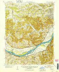
1949 Map of Augusta
USGS Topo · Published 1949About this map
The Missouri River carves a deep arc through this landscape just after the war, separating the floodplain agricultural tracts of Hancock Bottom and Labadie Bottoms from the northern bluffs. This 1949 edition captures a period of industrial and institutional importance, evidenced by the presence of the Weldon Spring Ordnance Works and the Emmaus Sanitarium. Small settlements and rural community hubs are clearly defined, including the riverside town of Augusta and inland villages like New Melle and Cappeln. A dense network of rural schools, such as Wide Awake Sch and Happy Glen Sch, reflects the dispersed population patterns of the era. Significant landmarks along the river include Tavern Rock Quarry and St Albans Island, while the Missouri Pacific railroad traces the southern bank through Boles and Labadie.
Find a feature on this map
72 named features on this map. Tap any name to fly to it.
Don’t see what you’re looking for? This feature index may not catch every label — zoom into the map to look around manually.
Map Details
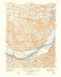
Editions of this 1949 Augusta Map
2 editions found
Other maps of this area

1890 · Hermann
USGS Topo · 1:125,000

1901 · De Soto
USGS Topo · 1:125,000

1903 · O'Fallon
USGS Topo · 1:125,000

1903 · Sullivan
USGS Topo · 1:125,000

1931 · Brussels
USGS Topo · 1:62,500

1937 · Pacific
USGS Topo · 1:24,000

1937 · Weldon Spring
USGS Topo · 1:24,000

1939 · Brussels
USGS Topo · 1:62,500

1940 · Eureka
USGS Topo · 1:24,000

1940 · Weldon Spring
USGS Topo · 1:24,000