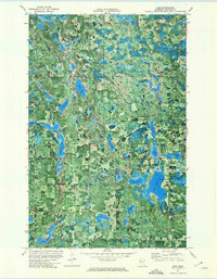
1972 Map of Aure
USGS Topo · Published 1974About this map
The Aure quadrangle is characterized by an intricate network of wetlands and glacial lakes, a landscape that defined the townships of Roosevelt, Maple Ridge, Buzzle, and Liberty in the early 1970s. The northern portion of the map is bordered by the Red Lake Ind Res, while the southern reaches are dominated by the Long Lake State Wildlife Management Area, which encompasses the sizable Deer Lake. These conservation and tribal lands emphasize a region largely shaped by the natural environment rather than dense urban development.
Find a feature on this map
26 named features on this map. Tap any name to fly to it.
Don’t see what you’re looking for? This feature index may not catch every label — zoom into the map to look around manually.
Map Details
Editions of this 1972 Aure Map
This is the sole edition of this map. No revisions or reprints were ever made.
Other maps of this area

1919 · Solway
USGS Topo · 1:62,500

1920 · Buena Vista
USGS Topo · 1:62,500

1943 · Solway
USGS Topo · 1:62,500

1954 · Bemidji
USGS Topo · 1:250,000

1957 · Bemidji
USGS Topo · 1:250,000

1958 · Bemidji
USGS Topo · 1:250,000

1972 · Bagley Lake
USGS Topo · 1:24,000

1972 · Peterson Lake
USGS Topo · 1:24,000

1972 · Redby
USGS Topo · 1:24,000
1972 · Debs
USGS Topo · 1:24,000