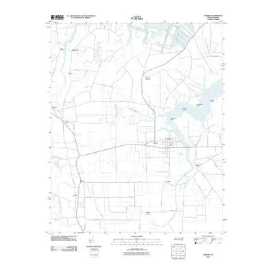
2010 Map of Aurora
USGS Topo · Published 2010About this map
South Creek and its many fingers, including Whitehurst Creek and Bailey Creek, dominate this landscape of the inner coastal plain. The town of Aurora serves as a central hub, where the Aurora Post Office and High Hill Cemetery sit near the water's edge. To the north, the massive Texasgulf Phosphate Operation highlights the region's industrial scale, contrasting with the quiet residential patterns of smaller settlements like Bonnerton, Idalia, and Royal.
Find a feature on this map
66 named features on this map. Tap any name to fly to it.
Don’t see what you’re looking for? This feature index may not catch every label — zoom into the map to look around manually.
Map Details
Editions of this 2010 Aurora Map
This is the sole edition of this map. No revisions or reprints were ever made.
Other maps of this area

1950 · Vandemere
USGS Topo · 1:24,000

1950 · South Creek
USGS Topo · 1:24,000

1950 · Aurora
USGS Topo · 1:24,000

1950 · Edward
USGS Topo · 1:24,000

1951 · Bath
USGS Topo · 1:24,000

1951 · Ransomville
USGS Topo · 1:24,000

1953 · Blounts Bay
USGS Topo · 1:24,000

1953 · Rocky Mount
USGS Topo · 1:250,000

1954 · Rocky Mount
USGS Topo · 1:250,000
1968 · Bayboro
USGS Topo · 1:24,000