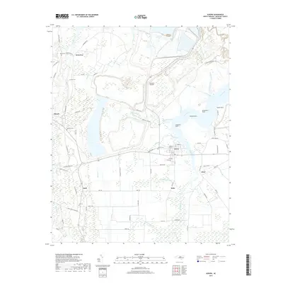
2019 Map of Aurora
USGS Topo · Published 2019About this map
Aurora serves as the primary hub of this Beaufort County landscape, situated at the junction of the coastal wetlands and agricultural lowlands. The surrounding territory is defined by the winding reaches of South Creek and its many tributaries, including Whitehurst Creek and Jacks Creek, which carve into the terrain to create distinct points like Holland Point and Silverthorn Point. The settlement pattern follows the drainage, with small communities such as Bonnerton, Idalia, and Royal established along local road networks like Royal Hwy and Idalia Rd.
Find a feature on this map
85 named features on this map. Tap any name to fly to it.
Don’t see what you’re looking for? This feature index may not catch every label — zoom into the map to look around manually.
Map Details
Editions of this 2019 Aurora Map
This is the sole edition of this map. No revisions or reprints were ever made.
Other maps of this area

1950 · Vandemere
USGS Topo · 1:24,000

1950 · South Creek
USGS Topo · 1:24,000

1950 · Aurora
USGS Topo · 1:24,000

1950 · Edward
USGS Topo · 1:24,000

1951 · Bath
USGS Topo · 1:24,000

1951 · Ransomville
USGS Topo · 1:24,000

1953 · Blounts Bay
USGS Topo · 1:24,000

1953 · Rocky Mount
USGS Topo · 1:250,000

1954 · Rocky Mount
USGS Topo · 1:250,000
1968 · Bayboro
USGS Topo · 1:24,000