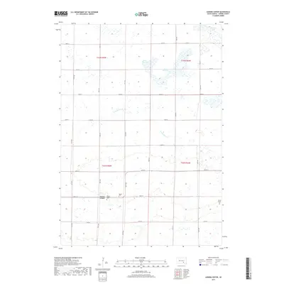
2017 Map of Aurora Center
USGS Topo · Published 2017About this map
Aurora Center serves as the focal point of this agricultural landscape in Truro Township, situated near the intersection of 266th St and 380th Ave. The map documents a classic South Dakota section-line road grid that organizes the terrain into tidy squares, occasionally interrupted by the winding path of E Fork Platte Cr. For genealogists and local historians, the sheet preserves the locations of two burial grounds: Aurora Center Cem and Quaker Cem, both situated east of the central settlement. The northern portion of the quadrangle is defined by a significant wetland and prairie pothole system, including the distinctive Horse Shoe Lake and the nearby Pleasant Lake. This network of seasonal water bodies and creeks illustrates the natural drainage patterns that have historically shaped land use and ranching boundaries throughout Aurora County.
Find a feature on this map
27 named features on this map. Tap any name to fly to it.
Don’t see what you’re looking for? This feature index may not catch every label — zoom into the map to look around manually.
Map Details
Editions of this 2017 Aurora Center Map
This is the sole edition of this map. No revisions or reprints were ever made.
Other maps of this area

1899 · Mitchell
USGS Topo · 1:125,000

1955 · Mitchell
USGS Topo · 1:250,000

1959 · Mitchell
USGS Topo · 1:250,000

1979 · New Holland
USGS Topo · 1:24,000

1979 · Laffey Lake
USGS Topo · 1:24,000

1979 · Crystal Lake
USGS Topo · 1:24,000

1979 · White Lake
USGS Topo · 1:24,000

1979 · Aurora Center
USGS Topo · 1:24,000

1979 · Joubert
USGS Topo · 1:24,000

1980 · Stickney
USGS Topo · 1:24,000
Featured Places
- Truro Township, SD
- Crystal Lake Township, SD
- Pleasant Lake Township, SD
- Center Township, SD
- Aurora Center, SD