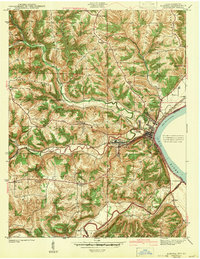
1943 Map of Aurora
USGS Topo · Published 1943About this map
Aurora serves as the focal point of this river-front landscape, where the Ohio River meets a network of vital tributaries. The town’s industrial and transit importance is marked by the presence of the Baltimore and Ohio and New York Central railroads, which parallel the riverbanks and cut through the hills. Just inland, the settlement of Cochran sits along the winding path of Hogan Creek, reflecting a settlement pattern deeply tied to the valley floor.
Find a feature on this map
36 named features on this map. Tap any name to fly to it.
Don’t see what you’re looking for? This feature index may not catch every label — zoom into the map to look around manually.
Map Details
Editions of this 1943 Aurora Map
2 editions found
Other maps of this area

1915 · Lawrenceburg
USGS Topo · 1:48,000

1928 · Lawrenceburg
USGS Topo · 1:62,500

1932 · Lawrenceburg
USGS Topo · 1:62,500

1943 · Aberdeen
USGS Topo · 1:24,000

1943 · Aurora
USGS Topo · 1:24,000

1943 · Rising Sun
USGS Topo · 1:24,000

1943 · Hooven
USGS Topo · 1:24,000

1943 · Guilford
USGS Topo · 1:24,000

1943 · Lawrenceburg
USGS Topo · 1:24,000

1951 · Rising Sun
USGS Topo · 1:24,000