
1953 Map of Aurora
USGS Topo · Published 1955About this map
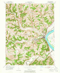
Aurora and the neighboring settlement of Cochran sit at the confluence of North Hogan Creek and the Ohio River, serving as a vital transportation hub during the mid-1950s. The landscape is defined by the heavy infrastructure of the Baltimore and Ohio railroad, which traces the shoreline and cuts through the interior ridges. The transition from active rural life to a changing post-war landscape is evident in the presence of educational landmarks like the Worley Sch (Abandoned) and the Plum Point Sch (Abandoned). Steep terrain like Wilmington Ridge and Mt Tabor Ridge separates the creek valleys, while community life is anchored by country churches such as Mt Tabor Ch and Ebenezer Ch. To the north, the Drive-in Theater and Dearborn Country Club reflect the mid-century expansion of recreational spaces near Lawrenceburg.
Find a feature on this map
39 named features on this map. Tap any name to fly to it.
Don’t see what you’re looking for? This feature index may not catch every label — zoom into the map to look around manually.
Map Details
Editions of this 1953 Aurora Map
2 editions found
Other maps of this area

1915 · Lawrenceburg
USGS Topo · 1:48,000

1928 · Lawrenceburg
USGS Topo · 1:62,500

1932 · Lawrenceburg
USGS Topo · 1:62,500

1943 · Aberdeen
USGS Topo · 1:24,000

1943 · Aurora
USGS Topo · 1:24,000

1943 · Rising Sun
USGS Topo · 1:24,000

1943 · Hooven
USGS Topo · 1:24,000

1943 · Guilford
USGS Topo · 1:24,000

1943 · Lawrenceburg
USGS Topo · 1:24,000

1951 · Rising Sun
USGS Topo · 1:24,000