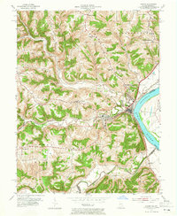
1953 Map of Aurora
USGS Topo · Published 1965About this map
The Ohio River shoreline anchors this mid-century survey, where the river town of Aurora serves as a vital transit point for the Baltimore and Ohio railroad. This industrial and transport hub is set against a landscape of prominent ridges, including Ebenezer Ridge and Washington Ridge, which overlook the winding paths of North Hogan Creek and South Hogan Creek. The map documents a period of transition, showing active social centers like the Dearborn Country Club and a Drive-in Theater alongside evidence of changing rural life.
Find a feature on this map
37 named features on this map. Tap any name to fly to it.
Don’t see what you’re looking for? This feature index may not catch every label — zoom into the map to look around manually.
Map Details
Editions of this 1953 Aurora Map
2 editions found

Other maps of this area

1915 · Lawrenceburg
USGS Topo · 1:48,000

1928 · Lawrenceburg
USGS Topo · 1:62,500

1932 · Lawrenceburg
USGS Topo · 1:62,500

1943 · Aberdeen
USGS Topo · 1:24,000

1943 · Aurora
USGS Topo · 1:24,000

1943 · Rising Sun
USGS Topo · 1:24,000

1943 · Hooven
USGS Topo · 1:24,000

1943 · Guilford
USGS Topo · 1:24,000

1943 · Lawrenceburg
USGS Topo · 1:24,000

1951 · Rising Sun
USGS Topo · 1:24,000