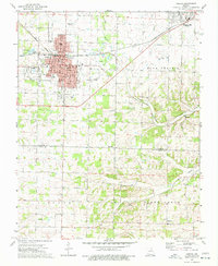
1974 Map of Aurora
USGS Topo · Published 1977About this map
Aurora serves as the primary urban hub on this 1970s landscape, positioned along the ST Louis-San Francisco railroad line. The town's grid is dense with civic and educational landmarks, including the City Hall, High Sch, and several neighborhood institutions like Lowell Sch and Robinson Sch. Just to the east, Marionville anchors the edge of Buck Prairie, while smaller settlements such as Osa and Revisville dot the rural landscape to the south. The terrain here transitions into the northern reaches of the O Z A R K plateau, characterized by winding watercourses like Crane Creek and Honey Creek.
Find a feature on this map
54 named features on this map. Tap any name to fly to it.
Don’t see what you’re looking for? This feature index may not catch every label — zoom into the map to look around manually.
Map Details
Editions of this 1974 Aurora Map
This is the sole edition of this map. No revisions or reprints were ever made.
Other maps of this area

1886 · Greenfield
USGS Topo · 1:125,000

1888 · Greenfield
USGS Topo · 1:125,000

1919 · Halltown
USGS Topo · 1:62,500

1921 · Stotts City
USGS Topo · 1:62,500

1942 · Aurora
USGS Topo · 1:62,500

1943 · Monett
USGS Topo · 1:62,500

1945 · Harrison
USGS Topo · 1:250,000

1945 · Aurora
USGS Topo · 1:62,500

1949 · Harrison
USGS Topo · 1:250,000

1954 · Harrison
USGS Topo · 1:250,000