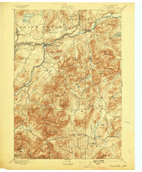
1895 Map of Ausable
USGS Topo · Published 1898About this map
Ausable Forks serves as the central hub of this 1890s Adirondack landscape, situated where the West Branch and East Branch converge. The iron industry and early transportation networks are clearly visible, with the D. and H. C. Co. R. R. rail line following the river valley through Rogers and Clintonville. Further south, the presence of Towers Forge and various family-named landmarks like Mr. Fay and Hale Hill reflect the era's small-scale industrial and agricultural footprint in the shadow of high peaks.
Find a feature on this map
73 named features on this map. Tap any name to fly to it.
Don’t see what you’re looking for? This feature index may not catch every label — zoom into the map to look around manually.
Map Details
Editions of this 1895 Ausable Map
2 editions found
Other maps of this area

1894 · Elizabethtown
USGS Topo · 1:62,500

1894 · Port Henry
USGS Topo · 1:62,500

1894 · Plattsburg
USGS Topo · 1:62,500

1895 · Willsboro
USGS Topo · 1:62,500

1895 · Elizabethtown
USGS Topo · 1:62,500

1895 · Mt. Marcy
USGS Topo · 1:62,500

1895 · Ausable
USGS Topo · 1:62,500

1896 · Lake Placid
USGS Topo · 1:62,500

1898 · Port Henry
USGS Topo · 1:62,500

1898 · Lake Placid
USGS Topo · 1:62,500