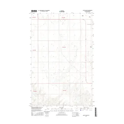
2017 Map of Austin Coulee
USGS Topo · Published 2017About this map
Austin Coulee and the surrounding high plains of Phillips County define this northern Montana landscape near the turn of the twenty-first century. The terrain is deeply incised by a network of drainage features, including Lush Coulee and Martins Coulee, which channel seasonal runoff through the arid prairie. The map captures a largely open, rural environment where human presence is marked primarily by the rigid grid of the Public Land Survey System, including boundaries for t35n r30e and t34n r30e. Infrastructure is sparse, concentrated along the Loring Cutacross Rd and US Highway 191. In the southwestern corner, Little Cottonwood Cr provides a subtle break in the topography, illustrating the vital role of watercourses in this ranching country.
Find a feature on this map
11 named features on this map. Tap any name to fly to it.
Don’t see what you’re looking for? This feature index may not catch every label — zoom into the map to look around manually.
Map Details
Editions of this 2017 Austin Coulee Map
This is the sole edition of this map. No revisions or reprints were ever made.
Other maps of this area

1920 · Cowan
USGS Topo · 1:125,000

1954 · Glasgow
USGS Topo · 1:250,000

1957 · Glasgow
USGS Topo · 1:250,000

1958 · Glasgow
USGS Topo · 1:250,000

1968 · Austin Lake
USGS Topo · 1:24,000

1968 · Hewitt Lake SW
USGS Topo · 1:24,000
1984 · Garland Creek
USGS Topo · 1:24,000

1984 · Austin Coulee
USGS Topo · 1:24,000

1984 · Whitewater West
USGS Topo · 1:24,000
1984 · Fanny Hill
USGS Topo · 1:24,000