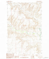
1984 Map of Fanny Hill
USGS Topo · Published 1984About this map
The Milk River winds through the southeastern corner of this Phillips County landscape, defining the local drainage and topography in the mid-1980s. This territory is characterized by a series of branching waterways, including Cottonwood Creek and its northern counterpart, Little Cottonwood Creek, which carve through the plains. The namesake Fanny Hill stands as a prominent elevation point overlooking the confluence of these stream systems. Evidence of ranching and land management appears in the network of unimproved roads and trails that traverse the coulees. The presence of Garland Creek and Austin Coulee further illustrates the complex erosion patterns typical of the region's geography, providing a clear record of the area's natural boundaries and accessible routes before more modern development.
Find a feature on this map
6 named features on this map. Tap any name to fly to it.
Don’t see what you’re looking for? This feature index may not catch every label — zoom into the map to look around manually.
Map Details
Editions of this 1984 Fanny Hill Map
This is the sole edition of this map. No revisions or reprints were ever made.
Other maps of this area

1905 · Bowdoin
USGS Topo · 1:62,500

1920 · Cowan
USGS Topo · 1:125,000

1954 · Glasgow
USGS Topo · 1:250,000

1957 · Glasgow
USGS Topo · 1:250,000

1958 · Glasgow
USGS Topo · 1:250,000
1968 · Malta NE
USGS Topo · 1:24,000

1968 · Austin Lake
USGS Topo · 1:24,000

1968 · Hewitt Lake SW
USGS Topo · 1:24,000
1968 · Malta NW
USGS Topo · 1:24,000
1984 · Garland Creek
USGS Topo · 1:24,000