
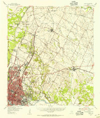
1954 Map of Austin East
USGS Topo · Published 1956About this map
The Colorado River serves as the southern anchor for this mid-century look at the state capital's eastward expansion. The urban footprint is dominated by institutional giants, most notably the University of Texas and Huston Tillotson College, alongside the expansive grounds of the Municipal Airport. This period reveals a landscape transitioning from the historic core toward new subdivisions, yet it remains anchored by significant cultural landmarks like the Elisabet Ney Museum and the French Embassy.
Find a feature on this map
86 named features on this map. Tap any name to fly to it.
Don’t see what you’re looking for? This feature index may not catch every label — zoom into the map to look around manually.
Map Details
Editions of this 1954 Austin East Map
This is the sole edition of this map. No revisions or reprints were ever made.
Other maps of this area

1896 · Austin
USGS Topo · 1:125,000

1897 · Austin
USGS Topo · 1:125,000

1910 · Austin
USGS Topo · 1:125,000

1932 · Mt. Bonnell
USGS Topo · 1:62,500

1954 · Austin West
USGS Topo · 1:24,000

1954 · Austin
USGS Topo · 1:250,000

1955 · Montopolis
USGS Topo · 1:24,000

1955 · Oak Hill
USGS Topo · 1:24,000

1955 · Montopolis
USGS Topo · 1:62,500
1955 · Austin
USGS Topo · 1:62,500