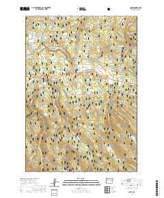
2020 Map of Austin
USGS Topo · Published 2020About this map
Austin sits at the western edge of this terrain in Grant County, where the Middle Fork John Day River winds through a landscape defined by expansive high-elevation openings. The geography is characterized by numerous named meadows and flats, including Japanese Meadow, Phipps Meadow, and Bjerkson Flat, which historically served as vital grazing and gathering grounds within the Malheur National Forest. The presence of the Austin Spur and various forest routes indicates a land managed for its timber and natural resources. Small waterways such as Phipps Cr and Wiwaanaytt Cr feed the larger river system, while isolated points like Quaking Aspen Spring and Rock Creek Spring provide essential water sources in the timbered uplands. The map reveals a remote intersection of natural hydrology and early 21st-century forest management.
Find a feature on this map
51 named features on this map. Tap any name to fly to it.
Don’t see what you’re looking for? This feature index may not catch every label — zoom into the map to look around manually.
Map Details
Editions of this 2020 Austin Map
This is the sole edition of this map. No revisions or reprints were ever made.
Other maps of this area

1901 · Sumpter
USGS Topo · 1:125,000

1908 · Ironside Mountain
USGS Topo · 1:125,000

1951 · Bates
USGS Topo · 1:62,500

1955 · Canyon City
USGS Topo · 1:250,000

1959 · Canyon City
USGS Topo · 1:250,000

1959 · Prairie City
USGS Topo · 1:62,500

1961 · Whitney
USGS Topo · 1:24,000

1972 · Austin
USGS Topo · 1:24,000
1972 · Deardorff Mtn
USGS Topo · 1:24,000

1972 · Greenhorn
USGS Topo · 1:24,000