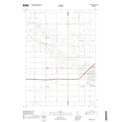
2019 Map of Austin West
USGS Topo · Published 2019About this map
The western edge of Austin and the neighboring agricultural lands of Mower and Freeborn counties define this 2019 survey. The landscape is characterized by a high concentration of wetlands and intricate drainage systems, including Judicial Ditch Number Five and Turtle Cr, which meander through the prairie terrain. Significant for local historians are the established rural settlements of Moscow and Oakland, alongside the residential pocket of Austin Acres. The map provides detailed placement of landmarks such as Riverland Community College and several historic burial sites, including Old Red Oak Grove Cem and Fairview Cem. A rectilinear grid of county roads and township lines organizes the territory, illustrating the modern rural-urban interface as the city limits of Austin extend toward the agricultural heartland of southern Minnesota.
Find a feature on this map
50 named features on this map. Tap any name to fly to it.
Don’t see what you’re looking for? This feature index may not catch every label — zoom into the map to look around manually.
Map Details
Editions of this 2019 Austin West Map
This is the sole edition of this map. No revisions or reprints were ever made.
Other maps of this area

1954 · Hayward
USGS Topo · 1:62,500

1954 · Austin
USGS Topo · 1:62,500

1954 · Mason City
USGS Topo · 1:250,000

1957 · Mason City
USGS Topo · 1:250,000

1958 · Mason City
USGS Topo · 1:250,000

1966 · Waltham
USGS Topo · 1:24,000

1967 · Blooming Prairie
USGS Topo · 1:24,000

1967 · Hollandale
USGS Topo · 1:24,000
1982 · Austin East
USGS Topo · 1:24,000

1982 · Hayward
USGS Topo · 1:24,000