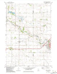
1982 Map of Austin West
USGS Topo · Published 1983About this map
The agrarian and industrial landscape of the Freeborn and Mower County line is defined by the steady drainage patterns of Turtle Creek and an extensive system of man-made waterways like Judicial Ditch No 24. At the center of this rural-to-urban transition, the town of Oakland sits along the tracks of the Chicago Milwaukee St Paul and Pacific railroad, reflecting the importance of rail transport to the region's grain and livestock economy in the early 1980s. To the northwest, the Carey State Wildlife Management Area and Hickory Lake provide a natural contrast to the structured grid of the surrounding townships. On the eastern edge of the sheet, the city of Austin expands into its western suburbs, including the residential pocket of Austin Acres and the Vo-Tech Sch, showing the growth of this regional hub beyond its historical center.
Find a feature on this map
24 named features on this map. Tap any name to fly to it.
Don’t see what you’re looking for? This feature index may not catch every label — zoom into the map to look around manually.
Map Details
Editions of this 1982 Austin West Map
This is the sole edition of this map. No revisions or reprints were ever made.
Other maps of this area

1954 · Hayward
USGS Topo · 1:62,500

1954 · Austin
USGS Topo · 1:62,500

1954 · Mason City
USGS Topo · 1:250,000

1957 · Mason City
USGS Topo · 1:250,000

1958 · Mason City
USGS Topo · 1:250,000

1966 · Waltham
USGS Topo · 1:24,000

1967 · Blooming Prairie
USGS Topo · 1:24,000

1967 · Hollandale
USGS Topo · 1:24,000
1982 · Austin East
USGS Topo · 1:24,000

1982 · Hayward
USGS Topo · 1:24,000