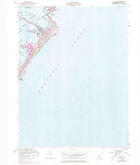
1953 Map of Avalon
USGS Topo · Published 1973About this map
Seven Mile Beach and the developed grid of Avalon dominate this coastal survey, showing the barrier island just before the major expansions of the late 20th century. The intricate system of man-made lagoons and harbors, including Pennsylvania Harbor, Princeton Harbor, and Cornell Harbor, illustrates the mid-century transformation of the Jersey Shore into a premier maritime destination. The Intracoastal Waterway threads through the sounds and thoroughfares behind the island, passing landmarks like the Avalon Yacht Club and the Toll Bridge at Townsends Inlet.
Find a feature on this map
28 named features on this map. Tap any name to fly to it.
Don’t see what you’re looking for? This feature index may not catch every label — zoom into the map to look around manually.
Map Details
Editions of this 1953 Avalon Map
4 editions found
Other maps of this area

1884 · Sea Isle
USGS Topo · 1:62,500

1888 · Cape May
USGS Topo · 1:62,500

1888 · Dennisville
USGS Topo · 1:62,500

1888 · Sea Isle
USGS Topo · 1:62,500

1893 · Cape May
USGS Topo · 1:62,500

1894 · Dennisville
USGS Topo · 1:62,500

1894 · Sea Isle
USGS Topo · 1:62,500

1898 · Cape May
USGS Topo · 1:62,500

1918 · Cape May
USGS Topo · 1:62,500

1919 · Sea Isle
USGS Topo · 1:62,500