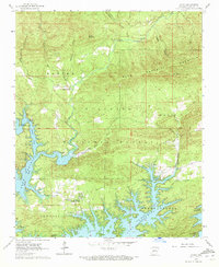
1962 Map of Avant
USGS Topo · Published 1972About this map
The Avant (Buckville PO) settlement and the historic community of Buckville anchor this 1960s survey of the Upper Ouachita River valley. This era reveals a landscape undergoing transformation as the Lake Ouachita reservoir reaches into the river's former drainage basin, creating new shorelines and recreational sites like the Irons Fork Recreational Area and Cedar Fourche Landing. Large tracts of the Ouachita National Forest dominate the central terrain, punctuated by family burial grounds such as Daley Cem and Caldwell Cem. High points like Blue Mountain and Pilot Knob provide a glimpse into the topographic character of the region before further development. The map also records early transport and spiritual hubs, including the Mount Tabor Ch and its neighboring Mount Tabor Cem, illustrating the deep-rooted rural infrastructure that existed alongside the winding course of North Fork Creek.
Find a feature on this map
32 named features on this map. Tap any name to fly to it.
Don’t see what you’re looking for? This feature index may not catch every label — zoom into the map to look around manually.
Map Details
Editions of this 1962 Avant Map
3 editions found
Other maps of this area

1890 · Hot Springs
USGS Topo · 1:125,000

1894 · Hot Springs
USGS Topo · 1:125,000

1955 · Little Rock
USGS Topo · 1:250,000

1956 · Little Rock
USGS Topo · 1:250,000

1960 · Little Rock
USGS Topo · 1:250,000

1962 · Crystal Springs
USGS Topo · 1:24,000

1962 · Avant
USGS Topo · 1:24,000

1962 · Fannie
USGS Topo · 1:24,000

1962 · Mc Graw Mountain
USGS Topo · 1:24,000

1964 · Little Rock
USGS Topo · 1:250,000