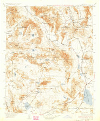
1933 Map of Avawatz Mountains
USGS Topo · Published 1974About this map
The Tonopah and Tidewater railroad corridor anchor this 1933 survey, tracing a path through the arid basin and range landscape from the Amargosa Range down to Baker. The region’s industrial history is etched into the terrain with sites like Ashford Mill, Confidence Mill, and the Epsom Salts Works, reflecting a period when remote mineral extraction drove settlement. Water sources were the vital lifeblood of the area, appearing as critical landmarks like Saratoga Spr, Resting Spr, and the Amargosa River.
Find a feature on this map
103 named features on this map. Tap any name to fly to it.
Don’t see what you’re looking for? This feature index may not catch every label — zoom into the map to look around manually.
Map Details
Editions of this 1933 Avawatz Mountains Map
5 editions found

Other maps of this area

1907 · Las Vegas
USGS Topo · 1:250,000

1908 · Furnace Creek
USGS Topo · 1:250,000

1908 · Las Vegas
USGS Topo · 1:250,000

1908 · Ballarat
USGS Topo · 1:250,000

1910 · Furnace Creek
USGS Topo · 1:250,000

1910 · Ivanpah
USGS Topo · 1:250,000

1912 · Ivanpah
USGS Topo · 1:250,000

1913 · Ballarat
USGS Topo · 1:250,000

1915 · Searles Lake
USGS Topo · 1:250,000

1932 · Barstow
USGS Topo · 1:125,000