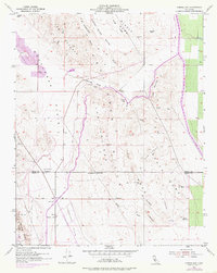
1954 Map of Avenal Gap
USGS Topo · Published 1976About this map
Kettleman Hills oil and gas infrastructure dominates this Central Valley landscape at the boundary of Kings and Kern counties. The map documents an industrial and agricultural frontier where the California Aqueduct carves through the terrain near Avenal Gap. The presence of a Farm Labor Camp and a Cotton Gin reflects the intensive labor and processing required by the region's mid-century agricultural economy. Geologically, the area is defined by a series of dramatic structural features including South Dome, Middle Dome, and Las Alturas. The transition from the Kettleman Plain to the Antelope Plain is marked by numerous oil wells and tanks, particularly around the settlement of Devils Den. This survey captures the massive scale of water engineering and petroleum extraction that reshaped this arid environment during the 1950s and early 1970s.
Find a feature on this map
42 named features on this map. Tap any name to fly to it.
Don’t see what you’re looking for? This feature index may not catch every label — zoom into the map to look around manually.
Map Details
Editions of this 1954 Avenal Gap Map
3 editions found
Other maps of this area

1914 · Lost Hills
USGS Topo · 1:125,000

1914 · Cholame
USGS Topo · 1:125,000

1915 · Cholame
USGS Topo · 1:125,000

1917 · Cholame
USGS Topo · 1:125,000

1930 · Avenal Gap
USGS Topo · 1:31,680

1930 · Kettleman Plain
USGS Topo · 1:31,680

1930 · Middle Dome
USGS Topo · 1:31,680

1932 · Dudley Ridge
USGS Topo · 1:31,680

1932 · Antelope Plain
USGS Topo · 1:31,680

1932 · West Camp
USGS Topo · 1:31,680