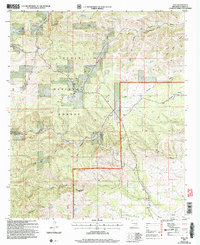
2004 Map of Avis
USGS Topo · Published 2006About this map
Lincoln National Forest lands dominate this high-desert terrain, where deep drainage systems like Dog Canyon and Bluewater Canyon define the movement of water across the Otero County landscape. The small settlement of Avis serves as a central landmark, supported by the presence of the Avis Cem and a nearby Airstrip. This 2004 revision reveals a ranching and rural economy reliant on scattered water infrastructure, evidenced by numerous named improvements such as Rainsplitter No 1 Tank, Irons Tank, and Daugherty Tank. To the south, the village of Piñon is documented alongside Piñon Creek and the Piñon Cem, illustrating the enduring nature of these small mountain communities. The topographic detail captures the transition from elevated canyon rims to the lower reaches of Barclay Draw and Behringer Canyon, providing a clear view of the area's geography prior to the mid-2000s.
Find a feature on this map
45 named features on this map. Tap any name to fly to it.
Don’t see what you’re looking for? This feature index may not catch every label — zoom into the map to look around manually.
Map Details
Editions of this 2004 Avis Map
This is the sole edition of this map. No revisions or reprints were ever made.
Other maps of this area

1952 · Cloudcroft
USGS Topo · 1:62,500

1954 · Carlsbad
USGS Topo · 1:250,000

1958 · Carlsbad
USGS Topo · 1:250,000

1963 · Cornucopia Canyon
USGS Topo · 1:24,000

1963 · Robertson Canyon
USGS Topo · 1:24,000

1963 · Woodson Canyon
USGS Topo · 1:24,000

1965 · Chimney Lake
USGS Topo · 1:24,000

1965 · Bear Spring
USGS Topo · 1:24,000

1965 · Surveyors Canyon
USGS Topo · 1:24,000

1965 · Avis
USGS Topo · 1:24,000