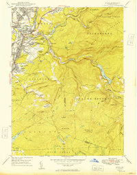
1949 Map of Avoca
USGS Topo · Published 1949About this map
The Lackawanna River corridor serves as the industrial heart of this 1949 survey, where the heavy infrastructure of the coal and rail era meets the emerging aviation age. The landscape is densely packed with the markers of anthracite history, from the Consolidated Breaker and Jermyn Breaker to the complex rail interconnections at Hillside Junction. While industrial activity dominates the river valley, the Scranton-Wilkes-Barre Airport sits atop a plateau between Avoca and Duryea, signifying a shift in transportation priorities during the mid-century.
Find a feature on this map
75 named features on this map. Tap any name to fly to it.
Don’t see what you’re looking for? This feature index may not catch every label — zoom into the map to look around manually.
Map Details
Editions of this 1949 Avoca Map
2 editions found
Other maps of this area

1889 · Scranton
USGS Topo · 1:62,500

1891 · Wilkesbarre
USGS Topo · 1:62,500

1891 · Scranton
USGS Topo · 1:62,500

1893 · Pittston
USGS Topo · 1:62,500

1893 · Scranton
USGS Topo · 1:62,500

1894 · Wilkesbarre
USGS Topo · 1:62,500

1922 · Stoddartsville
USGS Topo · 1:62,500

1924 · Stoddartsville
USGS Topo · 1:62,500

1943 · Scranton
USGS Topo · 1:125,000

1943 · Stoddartsville
USGS Topo · 1:62,500