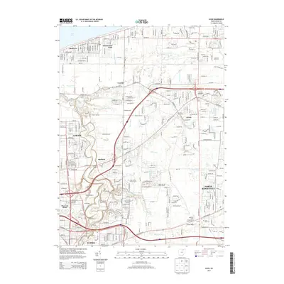
2013 Map of Avon
USGS Topo · Published 2013About this map
Lake Erie defines the northern reaches of this Lorain County landscape, where the lakefront residential character of Sheffield Lake and Lake Breeze transitions into a complex interior network of drainage ditches and creeks. The terrain is marked by historical ridges and watercourses like French Creek and the Black River, which have long shaped the settlement patterns of Avon, Sheffield, and North Ridgeville. The map reveals a dense layering of local history through its many cemeteries, including Saint Marys Catholic Cem and the Garfield Cem, alongside educational and transportation hubs like the Lorain County Community College campus and the Richards Airport. Infrastructure is a primary feature here, with the Norfolk and Western railroad and major thoroughfares like Colorado Ave and Detroit Rd facilitating the suburban growth that connects these established communities south of the lakeshore.
Find a feature on this map
50 named features on this map. Tap any name to fly to it.
Don’t see what you’re looking for? This feature index may not catch every label — zoom into the map to look around manually.
Map Details
Editions of this 2013 Avon Map
This is the sole edition of this map. No revisions or reprints were ever made.
Other maps of this area

1901 · Oberlin
USGS Topo · 1:62,500

1902 · Berea
USGS Topo · 1:62,500

1903 · Oberlin
USGS Topo · 1:62,500

1904 · Berea
USGS Topo · 1:62,500

1950 · Cleveland
USGS Topo · 1:250,000

1953 · West View
USGS Topo · 1:24,000

1953 · Grafton
USGS Topo · 1:24,000

1953 · Avon
USGS Topo · 1:24,000
1953 · North Olmsted
USGS Topo · 1:24,000

1956 · Cleveland
USGS Topo · 1:250,000