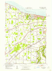
1953 Map of North Olmsted
USGS Topo · Published 1955About this map
The southern shoreline of Lake Erie defines the northern edge of this 1953 survey, a landscape transitioning from rural farmsteads to suburban development west of Cleveland. The topography is dominated by three distinct geological terraces—Middle Ridge, Ridge, and Butternut Ridge—which historically guided early road construction and settlement patterns. Local aviation is represented by Avon Airport and Strauss Airfield, while the emerging automotive era is marked by the path of the Ohio Turnpike near Ridgeville.
Find a feature on this map
54 named features on this map. Tap any name to fly to it.
Don’t see what you’re looking for? This feature index may not catch every label — zoom into the map to look around manually.
Map Details
Editions of this 1953 North Olmsted Map
This is the sole edition of this map. No revisions or reprints were ever made.
Other maps of this area

1901 · Oberlin
USGS Topo · 1:62,500

1902 · Berea
USGS Topo · 1:62,500

1903 · Oberlin
USGS Topo · 1:62,500

1904 · Berea
USGS Topo · 1:62,500

1950 · Cleveland
USGS Topo · 1:250,000

1953 · West View
USGS Topo · 1:24,000

1953 · Berea
USGS Topo · 1:24,000

1953 · Grafton
USGS Topo · 1:24,000

1953 · Avon
USGS Topo · 1:24,000
1953 · Lakewood
USGS Topo · 1:24,000