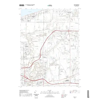
2019 Map of Avon
USGS Topo · Published 2019About this map
The Lake Erie shoreline and the complex hydrology of northern Lorain County define this contemporary landscape. This area is characterized by an intricate network of drainage channels, including Schumaker Ditch, Klingshirn Ditch, and Walker Ditch, which manage the low-lying terrain between the coastal settlements of Sheffield Lake and the inland growth of Avon. The meandering Black River cuts through the southwestern corner, adjacent to Elyria and the grounds of Richards Airport. Genealogists and local researchers will find a high density of burial sites across the quadrangle, from the Avon Cem and Saint Marys Catholic Cem in the east to the Garfield Cem and Day Cem further west. The map also documents the institutional footprint of the region, anchored by the Lorain County Community College and several parochial landmarks like Saint Peters Cem.
Find a feature on this map
49 named features on this map. Tap any name to fly to it.
Don’t see what you’re looking for? This feature index may not catch every label — zoom into the map to look around manually.
Map Details
Editions of this 2019 Avon Map
This is the sole edition of this map. No revisions or reprints were ever made.
Other maps of this area

1901 · Oberlin
USGS Topo · 1:62,500

1902 · Berea
USGS Topo · 1:62,500

1903 · Oberlin
USGS Topo · 1:62,500

1904 · Berea
USGS Topo · 1:62,500

1950 · Cleveland
USGS Topo · 1:250,000

1953 · West View
USGS Topo · 1:24,000

1953 · Grafton
USGS Topo · 1:24,000

1953 · Avon
USGS Topo · 1:24,000
1953 · North Olmsted
USGS Topo · 1:24,000

1956 · Cleveland
USGS Topo · 1:250,000