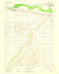
1960 Map of Avondale
USGS Topo · Published 1962About this map
Avondale and Boone serve as the primary hubs in this part of Pueblo County, where agricultural irrigation systems define the landscape south of the Arkansas River. The confluence of the river and the Huerfano River is surrounded by a complex network of man-made waterways, including the Colorado Canal, Bessemer Ditch, and Welton Ditch, illustrating the intensive water management required for farming in this semi-arid region. These canals hug the contours of the Badger Hills and Hooker Hills, separating the fertile river valley from the higher desert terrain. Cultural markers of the era include the site of Fort Reynolds and the San Jose Ch, along with a local Cem, providing evidence of the settled community's spiritual and historical roots. Industrial activity is indicated by several Gravel Pits concentrated near the rail and river corridors.
Find a feature on this map
17 named features on this map. Tap any name to fly to it.
Don’t see what you’re looking for? This feature index may not catch every label — zoom into the map to look around manually.
Map Details
Editions of this 1960 Avondale Map
4 editions found
Other maps of this area

1891 · Nepesta
USGS Topo · 1:125,000

1893 · Nepesta
USGS Topo · 1:125,000

1904 · Nepesta
USGS Topo · 1:125,000

1954 · Pueblo
USGS Topo · 1:250,000

1957 · Pueblo
USGS Topo · 1:250,000

1958 · Pueblo
USGS Topo · 1:250,000
1959 · Flying A Ranch
USGS Topo · 1:24,000
1960 · Nepesta
USGS Topo · 1:24,000
1960 · Boone Hill
USGS Topo · 1:24,000
1960 · Vineland
USGS Topo · 1:24,000