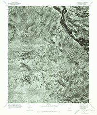
1971 Map of Avondale SE
USGS Topo · Published 1972About this map
The Sierra Estrella dominates this 1971 orthophotoquad, showing the raw topographic character of the Sonoran Desert in Maricopa County. Unlike a traditional line-and-symbol map, this aerial perspective reveals the intricate drainage patterns and sharp ridges of the mountain range before significant suburban expansion reached this portion of the valley. To the northeast, the braiding channels of the Gila River cut a dark, winding path through the landscape, providing a stark contrast to the surrounding arid terrain. The map captures the interface between the high desert peaks and the river valley at a time when the area remained largely undeveloped, preserving the natural flow of the alluvial fans and the structural geology of the range.
Find a feature on this map
2 named features on this map. Tap any name to fly to it.
Don’t see what you’re looking for? This feature index may not catch every label — zoom into the map to look around manually.
Map Details
Editions of this 1971 Avondale SE Map
This is the sole edition of this map. No revisions or reprints were ever made.
Other maps of this area

1912 · Phoenix
USGS Topo · 1:62,500

1913 · Maricopa
USGS Topo · 1:62,500

1914 · Phoenix
USGS Topo · 1:62,500

1915 · Maricopa
USGS Topo · 1:62,500

1946 · Avondale
USGS Topo · 1:62,500

1948 · Cashion
USGS Topo · 1:62,500

1951 · Mobile
USGS Topo · 1:62,500

1952 · Laveen
USGS Topo · 1:24,000

1952 · Montezuma Peak
USGS Topo · 1:24,000

1952 · Fowler
USGS Topo · 1:24,000