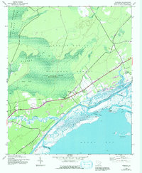
1943 Map of Awendaw
USGS Topo · Published 1992About this map
Tibwin Plantation and Laurel Hill Plantation stand as prominent landmarks in this coastal landscape, situated between the expansive timberlands of the Francis Marion National Forest and the tidal reaches of the Intracoastal Waterway. The settlement of Awendaw serves as a focal point along the highway, supported by local community structures like the St. James Sch and various clusters of homes at Pineland and Buck Hall.
Find a feature on this map
32 named features on this map. Tap any name to fly to it.
Don’t see what you’re looking for? This feature index may not catch every label — zoom into the map to look around manually.
Map Details
Editions of this 1943 Awendaw Map
5 editions found
Other maps of this area

1919 · Bulls Island
USGS Topo · 1:21,120

1919 · Sewee Bay
USGS Topo · 1:21,120

1942 · Mc Clellanville
USGS Topo · 1:24,000

1942 · Honey Hill
USGS Topo · 1:24,000

1943 · Sewee Bay
USGS Topo · 1:24,000

1943 · Bulls Island
USGS Topo · 1:24,000

1943 · Shulerville
USGS Topo · 1:24,000

1943 · Santee
USGS Topo · 1:24,000

1943 · Awendaw
USGS Topo · 1:24,000

1943 · Ocean Bay
USGS Topo · 1:24,000