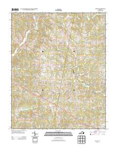
2013 Map of Axton
USGS Topo · Published 2013About this map
Axton serves as a central hub in this Virginia landscape, where numerous secondary roads converge in a pattern of rural settlement. The geography is defined by the winding course of the S Prong Sandy River and its many tributaries, such as Sugartree Cr and Cascade Cr, which have historically dictated the placement of homes and farms. Notable small communities like Soapstone, Leatherwood, and Stockton are connected by a network of named lanes and ridge roads, including Mountain Valley Rd and Jones Ridge Rd. To the north, Glady Fork Mountain rises above the drainage of Glady Fork, while landmarks like Davis Field Airport and Camp Axton reflect the modern utility and recreational use of the land. This survey provides a clear view of the area's transition from traditional homesteads like Burnt Chimneys and Boxwood to contemporary residential developments.
Find a feature on this map
116 named features on this map. Tap any name to fly to it.
Don’t see what you’re looking for? This feature index may not catch every label — zoom into the map to look around manually.
Map Details
Editions of this 2013 Axton Map
This is the sole edition of this map. No revisions or reprints were ever made.
Other maps of this area

1922 · Callands
USGS Topo · 1:48,000

1924 · Martinsville
USGS Topo · 1:48,000

1924 · Draper
USGS Topo · 1:48,000

1924 · Callands
USGS Topo · 1:62,500

1925 · Rocky Mount
USGS Topo · 1:48,000

1926 · Martinsville
USGS Topo · 1:62,500

1926 · Draper
USGS Topo · 1:62,500

1927 · Rocky Mount
USGS Topo · 1:62,500

1927 · Martinsville
USGS Topo · 1:62,500

1944 · Martinsville
USGS Topo · 1:62,500