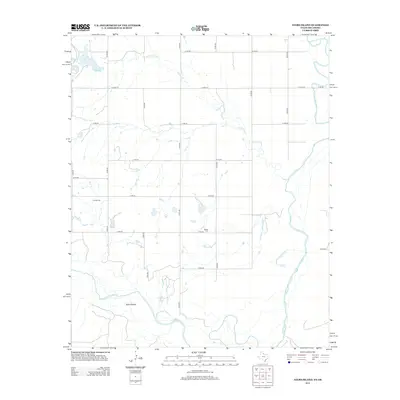
2012 Map of Ayers Island
USGS Topo · Published 2012About this map
Ayers Island anchors the southern edge of this Oklahoma-Texas borderlands survey, where the Red River defines the winding boundary between Jackson County and the neighboring territory. The landscape is characterized by a high-density grid of rural roads, including N1970 Rd and E1760 Rd, which partition the agricultural and ranching tracts. Along the northern reaches, Gypsum Cr and the Salt Fork Red River provide the primary drainage for the area. Local history is anchored by the presence of Carmel Cem in the west and Boggy Cem to the east, markers of the communities that have long worked this river-fed terrain. The eastern edge of the map identifies an area simply as Ranchland, reflecting the persistent cattle and livestock economy that continues to shape the local geography.
Find a feature on this map
23 named features on this map. Tap any name to fly to it.
Don’t see what you’re looking for? This feature index may not catch every label — zoom into the map to look around manually.
Map Details
Editions of this 2012 Ayers Island Map
This is the sole edition of this map. No revisions or reprints were ever made.
Other maps of this area

1955 · Lawton
USGS Topo · 1:250,000

1958 · Elmer
USGS Topo · 1:62,500

1960 · Quanah
USGS Topo · 1:62,500

1963 · Altus SE
USGS Topo · 1:24,000

1964 · Olustee
USGS Topo · 1:24,000

1971 · Prairie Hill
USGS Topo · 1:24,000

1975 · Elmore City NE
USGS Topo · 1:24,000

1975 · Quanah NE
USGS Topo · 1:24,000
1984 · Elmer
USGS Topo · 1:24,000
1984 · Quanah NE
USGS Topo · 1:24,000