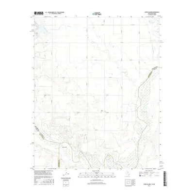
2016 Map of Ayers Island
USGS Topo · Published 2016About this map
Red River currents define the border landscape between Jackson County, Oklahoma, and the Texas counties of Wilbarger and Hardeman. This 2016 survey highlights the complex hydrography of the region, where the Salt Fork Red River joins the main stem near Ayers Island. The terrain is marked by a grid of rural roads, such as E1780 Rd and N1970 Rd, which navigate the drainages of Gypsum Cr and lead toward historical landmarks. Genealogists will find the locations of Carmel Cem in the west and Boggy Cem further east, providing vital points of reference for families tied to these prairie lands. The presence of Mitchell Lake and various wetland areas along the river bottoms illustrates the seasonal nature of water in this semi-arid agricultural environment.
Find a feature on this map
25 named features on this map. Tap any name to fly to it.
Don’t see what you’re looking for? This feature index may not catch every label — zoom into the map to look around manually.
Map Details
Editions of this 2016 Ayers Island Map
This is the sole edition of this map. No revisions or reprints were ever made.
Other maps of this area

1955 · Lawton
USGS Topo · 1:250,000

1958 · Elmer
USGS Topo · 1:62,500

1960 · Quanah
USGS Topo · 1:62,500

1963 · Altus SE
USGS Topo · 1:24,000

1964 · Olustee
USGS Topo · 1:24,000

1971 · Prairie Hill
USGS Topo · 1:24,000

1975 · Elmore City NE
USGS Topo · 1:24,000

1975 · Quanah NE
USGS Topo · 1:24,000
1984 · Elmer
USGS Topo · 1:24,000
1984 · Quanah NE
USGS Topo · 1:24,000