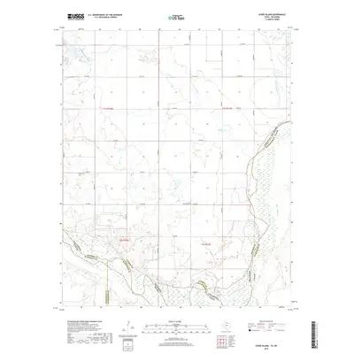
2019 Map of Ayers Island
USGS Topo · Published 2019About this map
The Red River defines the sweeping border between Oklahoma and Texas on this 2019 survey, where the riverbed spreads across a wide, complex network of channels and sandbars. Along this interstate boundary, Jackson County, Oklahoma meets Hardeman and Wilbarger Counties in Texas. The landscape is marked by the confluence of the Salt Fork Red River and the meandering path of Gypsum Cr, illustrating the hydraulic forces that have shaped this borderland. For those researching local history, the map identifies small, inland landmarks such as Carmel Cem and Boggy Cem, which stand as quiet markers of rural settlement amidst the expansive agricultural grid. The presence of Mitchell Lake near the river's edge further characterizes this riparian environment, where water management and natural drainage patterns dictate the layout of rural roads like e1780 RD.
Find a feature on this map
22 named features on this map. Tap any name to fly to it.
Don’t see what you’re looking for? This feature index may not catch every label — zoom into the map to look around manually.
Map Details
Editions of this 2019 Ayers Island Map
This is the sole edition of this map. No revisions or reprints were ever made.
Other maps of this area

1955 · Lawton
USGS Topo · 1:250,000

1958 · Elmer
USGS Topo · 1:62,500

1960 · Quanah
USGS Topo · 1:62,500

1963 · Altus SE
USGS Topo · 1:24,000

1964 · Olustee
USGS Topo · 1:24,000

1971 · Prairie Hill
USGS Topo · 1:24,000

1975 · Elmore City NE
USGS Topo · 1:24,000

1975 · Quanah NE
USGS Topo · 1:24,000
1984 · Elmer
USGS Topo · 1:24,000
1984 · Quanah NE
USGS Topo · 1:24,000