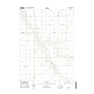
2016 Map of Ayersville
USGS Topo · Published 2016About this map
The agrarian landscape of northwest Ohio is documented here at the convergence of three counties, where the crossroads communities of Ayersville, Arthur, and Rice serve as local anchors. This region is characterized by its organized section lines and a drainage network that includes the winding Powell Cr and its tributaries, N Powell Cr and Hogback Run. The map provides significant detail for family historians, noting numerous small burial grounds such as Taylor Cem, Ice Cem, and Mount Zion Cem that dot the countryside.
Find a feature on this map
110 named features on this map. Tap any name to fly to it.
Don’t see what you’re looking for? This feature index may not catch every label — zoom into the map to look around manually.
Map Details
Editions of this 2016 Ayersville Map
This is the sole edition of this map. No revisions or reprints were ever made.
Other maps of this area

1907 · Defiance
USGS Topo · 1:62,500

1908 · Ottawa
USGS Topo · 1:62,500

1908 · Napoleon
USGS Topo · 1:62,500

1909 · Defiance
USGS Topo · 1:62,500

1909 · Continental
USGS Topo · 1:62,500

1953 · Fort Wayne
USGS Topo · 1:250,000

1956 · Fort Wayne
USGS Topo · 1:250,000

1959 · Defiance East
USGS Topo · 1:24,000

1959 · Florida
USGS Topo · 1:24,000
1960 · Oakwood
USGS Topo · 1:24,000