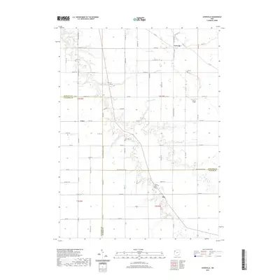
2019 Map of Ayersville
USGS Topo · Published 2019About this map
The agricultural landscape of Northwest Ohio is defined here by the confluence of numerous meandering waterways, including Powell Cr, Eagle Cr, and Wagner Run. In this corner of Defiance and Paulding counties, the small settlements of Ayersville, Arthur, and Rice serve as local anchors connected by a precise grid of rural township roads. The map reveals a high density of small family or community burial grounds, such as Taylor Cem, Ice Cem, and Myers Cem, which offer significant value for genealogical research. The terrain is marked by the shifting boundaries of several townships and the proximity of Blevins Airport. This survey provides a clear view of the intersection of traditional land use and modern infrastructure, where established farmsteads sit alongside modern developments like S Jefferson Ave.
Find a feature on this map
74 named features on this map. Tap any name to fly to it.
Don’t see what you’re looking for? This feature index may not catch every label — zoom into the map to look around manually.
Map Details
Editions of this 2019 Ayersville Map
This is the sole edition of this map. No revisions or reprints were ever made.
Other maps of this area

1907 · Defiance
USGS Topo · 1:62,500

1908 · Ottawa
USGS Topo · 1:62,500

1908 · Napoleon
USGS Topo · 1:62,500

1909 · Defiance
USGS Topo · 1:62,500

1909 · Continental
USGS Topo · 1:62,500

1953 · Fort Wayne
USGS Topo · 1:250,000

1956 · Fort Wayne
USGS Topo · 1:250,000

1959 · Defiance East
USGS Topo · 1:24,000

1959 · Florida
USGS Topo · 1:24,000
1960 · Oakwood
USGS Topo · 1:24,000