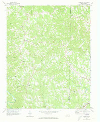
1971 Map of Ayersville
USGS Topo · Published 1973About this map
The Dan River curves through the southwestern corner of this 1970s landscape, while the interior is defined by a dense network of watercourses including Big Beaver Island Creek, Buffalo Creek, and Reed Creek. Small rural communities and crossroads settlements such as Sandy Ridge, Ayersville, and Dodgetown anchor the hills of Stokes and Rockingham counties. The map reflects a deeply established social fabric evidenced by numerous country churches, including Oak Grove Ch, Mt Hermon Ch, and Bethesda Ch. Local historians will find the terrain marked by several unnamed cemeteries and the Byrd Memorial near Madison. The distribution of structures along secondary roads and occasional Jeep Trails illustrates the persistent rural character of this Piedmont region decades after the initial photogrammetric surveys of the mid-1960s.
Find a feature on this map
32 named features on this map. Tap any name to fly to it.
Don’t see what you’re looking for? This feature index may not catch every label — zoom into the map to look around manually.
Map Details
Editions of this 1971 Ayersville Map
2 editions found
Other maps of this area

1924 · Martinsville
USGS Topo · 1:48,000

1926 · Martinsville
USGS Topo · 1:62,500

1926 · Critz
USGS Topo · 1:48,000

1927 · Martinsville
USGS Topo · 1:62,500

1928 · Critz
USGS Topo · 1:62,500

1944 · Martinsville
USGS Topo · 1:62,500

1953 · Winston-Salem
USGS Topo · 1:250,000

1953 · Greensboro
USGS Topo · 1:250,000

1954 · Greensboro
USGS Topo · 1:250,000

1955 · Winston-Salem
USGS Topo · 1:250,000