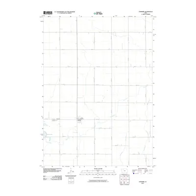
2010 Map of Ayrshire
USGS Topo · Published 2010About this map
The small town of Ayrshire serves as the central point of interest in this Palo Alto County landscape, where the grid of rural section roads meets the natural drainage patterns of north-central Iowa. The settlement is anchored by the Ayrshire Post Office and bordered by two burial grounds on its western edge, Calvary Cemetery and Silver Lake Cemetery. The topography is defined by the slow-moving waters of Silver Creek, which meanders through the central and southern portions of the sheet before converging with other drainages. This map shows the area in the early 21st century, illustrating how the rectilinear road system, including 390th St and 400th Ave, manages the agricultural territory around Silver Lake. Water management is a primary feature of the terrain, visible through the persistent flows of Beaver Creek and Pilot Creek that intersect the vast farmland.
Find a feature on this map
24 named features on this map. Tap any name to fly to it.
Don’t see what you’re looking for? This feature index may not catch every label — zoom into the map to look around manually.
Map Details
Editions of this 2010 Ayrshire Map
This is the sole edition of this map. No revisions or reprints were ever made.
Other maps of this area

1954 · Fairmont
USGS Topo · 1:250,000

1954 · Fort Dodge
USGS Topo · 1:250,000

1957 · Fort Dodge
USGS Topo · 1:250,000

1958 · Fort Dodge
USGS Topo · 1:250,000

1958 · Fairmont
USGS Topo · 1:250,000

1971 · Rush Lake East
USGS Topo · 1:24,000

1971 · Rush Lake West
USGS Topo · 1:24,000

1972 · Graettinger West
USGS Topo · 1:24,000

1972 · Ayrshire
USGS Topo · 1:24,000
1972 · Silver Lake
USGS Topo · 1:24,000