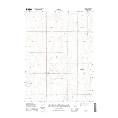
2015 Map of Ayrshire
USGS Topo · Published 2015About this map
Ayrshire serves as the central hub of this Palo Alto County landscape, where the town grid is defined by streets like Ayr St and Allowa St. The surrounding terrain is a complex network of managed waterways, featuring several engineered channels such as Ditch Number 6, Ditch Number 23, and Ditch Number 176 that navigate between natural flows like Silver Cr and Beaver Cr. This pattern of drainage reflects the agricultural necessity of moving water through the low-lying prairie lands of northern Iowa. To the southwest of the town site, Silver Lake provides a significant natural landmark, flanked by the Calvary Cem and Silver Lake Cem. The map illustrates a strictly organized section-line road system, with thoroughfares like Co Hwy B53 and Co Hwy N28 connecting the dispersed farmsteads of the T95N and T96N townships.
Find a feature on this map
38 named features on this map. Tap any name to fly to it.
Don’t see what you’re looking for? This feature index may not catch every label — zoom into the map to look around manually.
Map Details
Editions of this 2015 Ayrshire Map
This is the sole edition of this map. No revisions or reprints were ever made.
Other maps of this area

1954 · Fairmont
USGS Topo · 1:250,000

1954 · Fort Dodge
USGS Topo · 1:250,000

1957 · Fort Dodge
USGS Topo · 1:250,000

1958 · Fort Dodge
USGS Topo · 1:250,000

1958 · Fairmont
USGS Topo · 1:250,000

1971 · Rush Lake East
USGS Topo · 1:24,000

1971 · Rush Lake West
USGS Topo · 1:24,000

1972 · Graettinger West
USGS Topo · 1:24,000

1972 · Ayrshire
USGS Topo · 1:24,000
1972 · Silver Lake
USGS Topo · 1:24,000