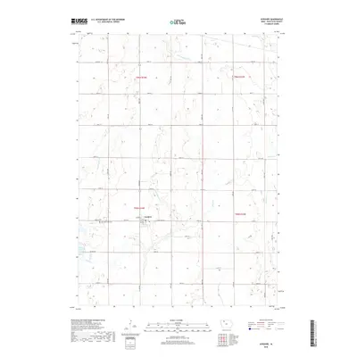
2018 Map of Ayrshire
USGS Topo · Published 2018About this map
Ayrshire serves as the central hub of this Palo Alto County landscape, where the rectilinear grid of country roads meets the fluid geography of the Iowa prairie. The town is flanked by the Silver Lake Cem and Calvary Cem, situated just north of the waters of Silver Lake. The surrounding terrain is defined by an extensive water management system, illustrated by engineered channels such as Ditch Number 176, Ditch Number 6, and Ditch Number 23. These ditches augment the natural drainage provided by Silver Cr and Beaver Cr, reflecting the long-standing agricultural priority of reclaiming the wetlands for cultivation. The map captures the enduring township and range structure, marked by significant boundaries like t95n r34w, that has governed this rural landscape since early settlement.
Find a feature on this map
35 named features on this map. Tap any name to fly to it.
Don’t see what you’re looking for? This feature index may not catch every label — zoom into the map to look around manually.
Map Details
Editions of this 2018 Ayrshire Map
This is the sole edition of this map. No revisions or reprints were ever made.
Other maps of this area

1954 · Fairmont
USGS Topo · 1:250,000

1954 · Fort Dodge
USGS Topo · 1:250,000

1957 · Fort Dodge
USGS Topo · 1:250,000

1958 · Fort Dodge
USGS Topo · 1:250,000

1958 · Fairmont
USGS Topo · 1:250,000

1971 · Rush Lake East
USGS Topo · 1:24,000

1971 · Rush Lake West
USGS Topo · 1:24,000

1972 · Graettinger West
USGS Topo · 1:24,000

1972 · Ayrshire
USGS Topo · 1:24,000
1972 · Silver Lake
USGS Topo · 1:24,000