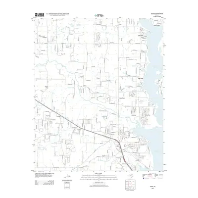
2012 Map of Azle
USGS Topo · Published 2012About this map
Eagle Mountain Lake dominates the eastern edge of this landscape, its western shoreline defining the suburban and semi-rural expansion north of Fort Worth. The city of Azle serves as the primary hub at the southern end, where residential grids meet the water at developments like Pelican Bay and Eagle Acres. Moving west from the lake, the terrain transitions into a patchwork of small communities and homesteads including Reno, Sanctuary, and La Junta, connected by a network of ranch roads and wooded creek bottoms such as Walnut Cr and Ash Cr. Several family and community burial grounds, including Nelson Cem, Reynolds Cem, and Smith Frazier Cem, are preserved among the modern residential parcels. The presence of both Moore Private Airport and Kezer Air Ranch Airport underscores the region's aviation-linked residential character, common in this part of North Texas.
Find a feature on this map
47 named features on this map. Tap any name to fly to it.
Don’t see what you’re looking for? This feature index may not catch every label — zoom into the map to look around manually.
Map Details
Editions of this 2012 Azle Map
This is the sole edition of this map. No revisions or reprints were ever made.
Other maps of this area

1891 · Weatherford
USGS Topo · 1:125,000

1893 · Weatherford
USGS Topo · 1:125,000

1894 · Fort Worth
USGS Topo · 1:125,000

1924 · Sunset 4-d
USGS Topo · 1:48,000

1930 · Boyd
USGS Topo · 1:62,500

1932 · Springtown
USGS Topo · 1:62,500

1954 · Dallas
USGS Topo · 1:250,000

1954 · Sherman
USGS Topo · 1:250,000

1955 · Avondale
USGS Topo · 1:24,000

1955 · Azle
USGS Topo · 1:24,000