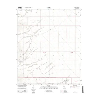
2015 Map of Aztec Mines
USGS Topo · Published 2015About this map
Aztec Mines sits within a landscape defined by seasonal watercourses and remote transit corridors in eastern Riverside County. This 2015 survey details the arid terrain where ephemeral drainages like Ship Cr cut through the desert floor, creating the characteristic alluvial patterns of the region. The map tracks the intersecting paths of legacy desert routes, including Dupont Rd, which traverses the central sections, and Chuckwalla Valley Rd in the northeast corner. Along the southern margin, the presence of Chuckwalla Springs Rd and Augustine Pass Rd indicates the historical importance of these corridors for accessing water sources and navigating the surrounding mountain passes. The spatial relationship between the mining operations and these primitive roads highlights the logistical challenges of industry in this part of the California desert.
Find a feature on this map
12 named features on this map. Tap any name to fly to it.
Don’t see what you’re looking for? This feature index may not catch every label — zoom into the map to look around manually.
Map Details
Editions of this 2015 Aztec Mines Map
This is the sole edition of this map. No revisions or reprints were ever made.
Other maps of this area

1940 · Iris Pass
USGS Topo · 1:62,500

1944 · Chuckwalla Mountains
USGS Topo · 1:62,500

1945 · Iris Pass
USGS Topo · 1:62,500

1952 · Sidewinder Well
USGS Topo · 1:62,500

1953 · Chuckwalla Spring
USGS Topo · 1:62,500

1954 · Salton Sea
USGS Topo · 1:250,000

1955 · Salton Sea
USGS Topo · 1:250,000

1959 · Salton Sea
USGS Topo · 1:250,000

1963 · Salton Sea
USGS Topo · 1:250,000
1963 · Iris Pass
USGS Topo · 1:62,500