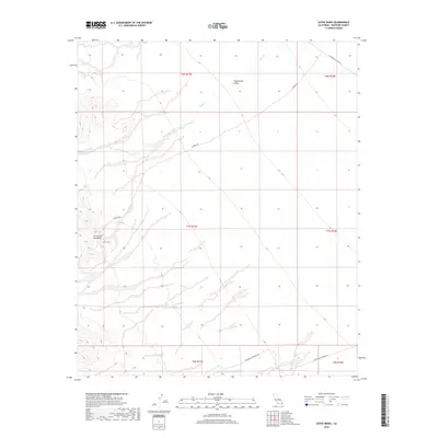
2018 Map of Aztec Mines
USGS Topo · Published 2018About this map
Aztec Mines sit at the southern edge of the Chuckwalla Mountains in Riverside County, marking a site of industrial effort in the arid California interior. This 2018 survey documents the relationship between the elevated mountain terrain and the expansive Chuckwalla Valley to the north, where the ephemeral Ship Creek drains through the alluvial landscape. The area is defined by a network of desert routes, including Chuckwalla Valley Rd and Dupont Rd, which facilitate access through these township and range divisions. The map reveals the stark topography of the region, where drainage patterns from the mountains intersect with the vast basins below, providing a record of local mining geography and desert infrastructure in the early twenty-first century.
Find a feature on this map
14 named features on this map. Tap any name to fly to it.
Don’t see what you’re looking for? This feature index may not catch every label — zoom into the map to look around manually.
Map Details
Editions of this 2018 Aztec Mines Map
This is the sole edition of this map. No revisions or reprints were ever made.
Other maps of this area

1940 · Iris Pass
USGS Topo · 1:62,500

1944 · Chuckwalla Mountains
USGS Topo · 1:62,500

1945 · Iris Pass
USGS Topo · 1:62,500

1952 · Sidewinder Well
USGS Topo · 1:62,500

1953 · Chuckwalla Spring
USGS Topo · 1:62,500

1954 · Salton Sea
USGS Topo · 1:250,000

1955 · Salton Sea
USGS Topo · 1:250,000

1959 · Salton Sea
USGS Topo · 1:250,000

1963 · Salton Sea
USGS Topo · 1:250,000
1963 · Iris Pass
USGS Topo · 1:62,500