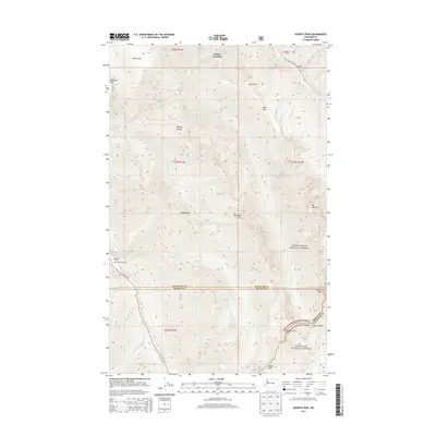
2014 Map of Azurite Peak
USGS Topo · Published 2014About this map
Cedar Crossing sits at the northern edge of this high-altitude landscape, where the headwaters of Slate Cr and Mill Cr carve through the North Cascades. The map documented the 2014 intersection of the Mount Baker National Forest and Okanogan National Forest, split by the county lines of Whatcom, Skagit, and Okanogan. High peaks like Azurite Peak and Mt Ballard dominate the eastern topography, while the southern reaches are accessed via the North Cascades Highway. The presence of Fourmile Camp and the East Creek Trailhead near North Granite Creek highlights the area's importance for backcountry navigation. Between the deep cleft of Rowley Chasm and the high saddles of Cady Pass and Mebee Pass, the map provides a precise record of the drainage patterns of Cabinet Creek and Boulder Creek in a transition zone of extreme relief.
Find a feature on this map
36 named features on this map. Tap any name to fly to it.
Don’t see what you’re looking for? This feature index may not catch every label — zoom into the map to look around manually.
Map Details
Editions of this 2014 Azurite Peak Map
This is the sole edition of this map. No revisions or reprints were ever made.
Other maps of this area

1920 · Slate Pass
USGS Topo · 1:125,000

1955 · Concrete
USGS Topo · 1:250,000

1958 · Concrete
USGS Topo · 1:250,000

1962 · Concrete
USGS Topo · 1:250,000

1963 · Washington Pass
USGS Topo · 1:24,000

1963 · Azurite Peak
USGS Topo · 1:24,000

1963 · Slate Peak
USGS Topo · 1:24,000
1963 · Mt. Arriva
USGS Topo · 1:24,000
1963 · Mt Logan
USGS Topo · 1:24,000

1963 · Crater Mountain
USGS Topo · 1:24,000