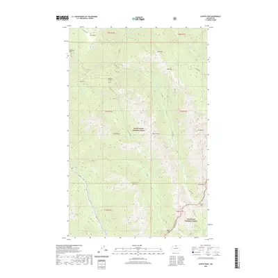
2020 Map of Azurite Peak
USGS Topo · Published 2020About this map
Azurite Peak and the high ridges of the North Cascades define this landscape where the boundaries of Mount Baker National Forest and Okanogan National Forest converge. The terrain is marked by a network of drainage systems, including the headwaters of the Methow River and Mill Cr, which carve through the high-elevation passes of Azurite Pass and Mebee Pass. In the northern section, Rowley Chasm and Devils Park offer unique topographical relief alongside Jackita Ridge. This 2020 survey demonstrates the intersection of three Washington counties—Whatcom, Skagit, and Okanogan—meeting at the divide. Hikers and cartographers can trace established routes through Cady Pass or explore the drainage basins of Canyon Cr and Granite Cr, which illustrate the complex water systems feeding the region's larger rivers.
Find a feature on this map
43 named features on this map. Tap any name to fly to it.
Don’t see what you’re looking for? This feature index may not catch every label — zoom into the map to look around manually.
Map Details
Editions of this 2020 Azurite Peak Map
This is the sole edition of this map. No revisions or reprints were ever made.
Other maps of this area

1920 · Slate Pass
USGS Topo · 1:125,000

1955 · Concrete
USGS Topo · 1:250,000

1958 · Concrete
USGS Topo · 1:250,000

1962 · Concrete
USGS Topo · 1:250,000

1963 · Washington Pass
USGS Topo · 1:24,000

1963 · Azurite Peak
USGS Topo · 1:24,000

1963 · Slate Peak
USGS Topo · 1:24,000
1963 · Mt. Arriva
USGS Topo · 1:24,000
1963 · Mt Logan
USGS Topo · 1:24,000

1963 · Crater Mountain
USGS Topo · 1:24,000