1928 Map of Azusa
USGS Topo · Published 1928About this map
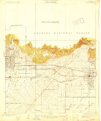
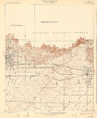
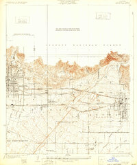
Sierra Madre peaks tower over the developing San Gabriel Valley in this mid-1920s survey, illustrating a landscape defined by its transition from steep canyons to alluvial plains. The residential and commercial blocks of Monrovia and Azusa are clearly established, while the citrus-growing heart of Duarte remains less densely settled. The local economy and transport network are dominated by three major rail lines: the Southern Pacific, the Pacific Electric, and the Atchison Topeka and Santa Fe, which cut through the gravel-rich flats near the San Gabriel River.
Find a feature on this map
32 named features on this map. Tap any name to fly to it.
Don’t see what you’re looking for? This feature index may not catch every label — zoom into the map to look around manually.
Map Details
Editions of this 1928 Azusa Map
3 editions found
Other maps of this area

1894 · Los Angeles
USGS Topo · 1:62,500

1894 · Pomona
USGS Topo · 1:62,500

1896 · Pasadena
USGS Topo · 1:62,500

1897 · Pomona
USGS Topo · 1:62,500

1898 · Pomona
USGS Topo · 1:62,500

1900 · Pasadena
USGS Topo · 1:62,500

1900 · Los Angeles
USGS Topo · 1:62,500

1901 · Southern California Sheet No. 1
USGS Topo · 1:250,000

1904 · Pomona
USGS Topo · 1:62,500

1904 · Southern California Sheet No. 1
USGS Topo · 1:250,000