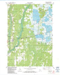
1984 Map of Babcock
USGS Topo · Published 1984About this map
Cranberry cultivation defines the landscape of central Wood County in this 1984 study, where extensive Cranberry Bogs and specialized water management systems dominate the terrain east of Hemlock Creek. The area is a mosaic of wetlands and small airfields, including the Brazeau Landing Strip and Whittlesey Landing Strip, which likely served the local agricultural industry. The settlement of Babcock sits at the junction of the Yellow River and the Chicago Milwaukee St Paul and Pacific railroad, serving as a hub for the surrounding townships of Dexter and Remington. To the west, the Sandhill State Wildlife Area provides a contrast of preserved natural space against the highly engineered bogs. Local genealogists will find value in the location of the Babcock Cem and the various family-named routes such as Mc Keel Road and Batterman Road.
Find a feature on this map
32 named features on this map. Tap any name to fly to it.
Don’t see what you’re looking for? This feature index may not catch every label — zoom into the map to look around manually.
Map Details
Editions of this 1984 Babcock Map
This is the sole edition of this map. No revisions or reprints were ever made.
Other maps of this area

1953 · Eau Claire
USGS Topo · 1:250,000

1955 · Green Bay
USGS Topo · 1:250,000

1957 · Wisconsin Rapids
USGS Topo · 1:48,000

1957 · Pittsville
USGS Topo · 1:48,000

1958 · Eau Claire
USGS Topo · 1:250,000

1958 · Arkdale
USGS Topo · 1:48,000

1958 · Necedah
USGS Topo · 1:48,000

1964 · Eau Claire
USGS Topo · 1:250,000

1967 · Wisconsin Rapids
USGS Topo · 1:62,500

1967 · Pittsville
USGS Topo · 1:62,500