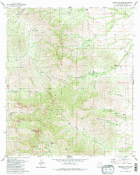
1979 Map of Baboquivari Peak
USGS Topo · Published 1983About this map
Baboquivari Peak serves as the dominant landmark of this high-desert landscape in the Baboquivari Mountains, a region defined by sharp vertical relief and essential water sources within the Papago Indian Reservation. The 1970s land use pattern is characterized by remote outposts such as Redondo Ranch and Elkhorn Ranch, connected by a network of seasonal washes like Redondo Wash and Sabino Wash. These ranches and several ruins indicate the persistent human effort to maintain a presence in the arid terrain, relying on scattered reliable points like Baboquivari Spring, Sycamore Spring, and Broken Trough Spring. The presence of various prospects scattered through Fresnal Canyon and Contreras Canyon points to the area's history of mineral exploration alongside its long-standing ranching traditions.
Find a feature on this map
33 named features on this map. Tap any name to fly to it.
Don’t see what you’re looking for? This feature index may not catch every label — zoom into the map to look around manually.
Map Details
Editions of this 1979 Baboquivari Peak Map
3 editions found
Other maps of this area

1920 · Arivaca
USGS Topo · 1:125,000

1940 · Palo Alto Ranch
USGS Topo · 1:62,500

1941 · Presumido Peak
USGS Topo · 1:62,500

1941 · Baboquivari Peak
USGS Topo · 1:62,500

1941 · Arivaca
USGS Topo · 1:62,500

1943 · Fresnal
USGS Topo · 1:125,000

1943 · Arivaca
USGS Topo · 1:62,500

1943 · Palo Alto Ranch
USGS Topo · 1:62,500

1943 · Presumido Peak
USGS Topo · 1:62,500

1944 · Baboquivari Peak
USGS Topo · 1:62,500