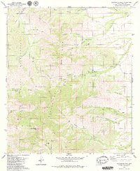
1979 Map of Baboquivari Peak
USGS Topo · Published 1979About this map
The Baboquivari Mountains dominate this landscape within the Papago Indian Reservation, centered on the striking elevation of Baboquivari Peak. This late-1970s survey captures a high-desert terrain defined by deep canyons and scattered water sources critical to the local ranching economy. Significant landmarks such as Redondo Ranch, Elkhorn Ranch, and Las Delicias Ranch are situated along the drainage systems of Sabino Wash and Chiltepines Wash.
Find a feature on this map
39 named features on this map. Tap any name to fly to it.
Don’t see what you’re looking for? This feature index may not catch every label — zoom into the map to look around manually.
Map Details
Editions of this 1979 Baboquivari Peak Map
3 editions found
Other maps of this area

1920 · Arivaca
USGS Topo · 1:125,000

1940 · Palo Alto Ranch
USGS Topo · 1:62,500

1941 · Presumido Peak
USGS Topo · 1:62,500

1941 · Baboquivari Peak
USGS Topo · 1:62,500

1941 · Arivaca
USGS Topo · 1:62,500

1943 · Fresnal
USGS Topo · 1:125,000

1943 · Arivaca
USGS Topo · 1:62,500

1943 · Palo Alto Ranch
USGS Topo · 1:62,500

1943 · Presumido Peak
USGS Topo · 1:62,500

1944 · Baboquivari Peak
USGS Topo · 1:62,500