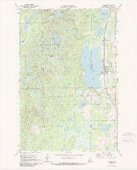
1970 Map of Backus
USGS Topo · Published 1987About this map
The town of Backus serves as a focal point on the eastern edge of this 1970s-era survey, positioned along the Burlington Northern railroad. The landscape is dominated by the sprawling waters of Pine Mountain Lake and a dense network of smaller basins such as Sleepy Island Lake and Ox Camp Lake. Within the Deerfield State Forest, the terrain rises toward the Foothills and Bull Moose areas, where the Pine Mountain Lookout Tower stands as a notable landmark for fire observation.
Find a feature on this map
39 named features on this map. Tap any name to fly to it.
Don’t see what you’re looking for? This feature index may not catch every label — zoom into the map to look around manually.
Map Details
Editions of this 1970 Backus Map
2 editions found
Other maps of this area

1919 · Leader
USGS Topo · 1:62,500

1953 · Brainerd
USGS Topo · 1:250,000

1957 · Brainerd
USGS Topo · 1:250,000

1958 · Brainerd
USGS Topo · 1:250,000

1959 · Pine River
USGS Topo · 1:24,000

1965 · Brainerd
USGS Topo · 1:250,000

1970 · Spider Lake
USGS Topo · 1:24,000

1970 · Backus
USGS Topo · 1:24,000

1970 · Hackensack
USGS Topo · 1:24,000
1970 · Bungo Creek
USGS Topo · 1:24,000