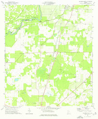
1974 Map of Baconton South
USGS Topo · Published 1976About this map
Baconton and the surrounding agricultural landscape of Mitchell County appear during a period of established rural community and transport infrastructure. The Flint River forms the western boundary, creating distinctive terrain features like Horseshoe Bend and Prossers Island while fed by local water sources such as Walton Spring and Double Springs. The map reveals a high density of rural institutions, with small churches and cemeteries like China Grove Cem and Beautiful Light Ch serving as focal points for the farming population. A dual rail network, consisting of the Seaboard Coast Line and the Georgia Northern, defines the economic corridor through Duffee and Flint. The landscape is further characterized by scattered wetlands and low-lying areas, including The Flat and Wethington Slough, which intersect with the grid of local thoroughfares like Hard Up Road.
Find a feature on this map
27 named features on this map. Tap any name to fly to it.
Don’t see what you’re looking for? This feature index may not catch every label — zoom into the map to look around manually.
Map Details
Editions of this 1974 Baconton South Map
This is the sole edition of this map. No revisions or reprints were ever made.
Other maps of this area

1953 · Dothan
USGS Topo · 1:250,000

1954 · Dothan
USGS Topo · 1:250,000

1955 · Dothan
USGS Topo · 1:250,000

1956 · Baconton
USGS Topo · 1:62,500

1956 · Newton
USGS Topo · 1:62,500

1971 · Camilla
USGS Topo · 1:24,000

1971 · Cotton
USGS Topo · 1:24,000
1971 · Branchville
USGS Topo · 1:24,000
1974 · Putney
USGS Topo · 1:24,000
1974 · Newton
USGS Topo · 1:24,000