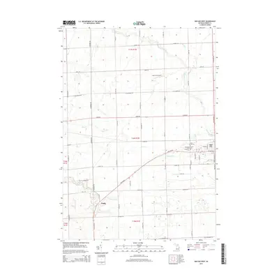
2014 Map of Bad Axe West
USGS Topo · Published 2014About this map
Bad Axe sits at the eastern edge of this Michigan landscape, where the grid of rural township roads meets the town's western outskirts. The terrain is defined by a series of waterways, most notably the Pinnebog River which winds through the southern and central sections, joined by Silver Cr and Bad Axe Cr. The map reflects a deeply established agricultural and civic layout, punctuated by local landmarks such as Engler Field Airport and the small settlement of Popple to the southwest. Genealogists will find particular value in the clearly marked Colfax Township Cem and Sacred Heart Roman Catholic Cem, located near the intersection of S Van Dyke Rd and Geiger Rd. This 2014 survey documents the enduring road network of Huron County, from arterial routes like N Van Dyke Rd to family-named local paths such as Glassburner Rd and McKenzie Rd.
Find a feature on this map
56 named features on this map. Tap any name to fly to it.
Don’t see what you’re looking for? This feature index may not catch every label — zoom into the map to look around manually.
Map Details
Editions of this 2014 Bad Axe West Map
This is the sole edition of this map. No revisions or reprints were ever made.
Other maps of this area

1954 · Flint
USGS Topo · 1:250,000

1958 · Flint
USGS Topo · 1:250,000

1963 · New Greenleaf
USGS Topo · 1:24,000

1963 · Ubly
USGS Topo · 1:24,000

1963 · Gagetown
USGS Topo · 1:24,000
1970 · Rush Lake
USGS Topo · 1:24,000

1970 · Kinde East
USGS Topo · 1:24,000

1970 · Kinde West
USGS Topo · 1:24,000

1970 · Bad Axe West
USGS Topo · 1:24,000
1970 · Elkton
USGS Topo · 1:24,000